logo here
logo here

Integrated Maritime Intelligence

Real-Time Maritime Awareness, Redefined

Navisense · NaviCube+ · NaviBased

Maritime Intelligence Suite

Integrated Maritime Intelligence from Shore to Space

Combine terrestrial AIS receivers, satellite AIS payloads and a unified maritime-data platform to improve vessel visibility, operational awareness and maritime-domain intelligence.

Navisense, NaviCube+ and NaviBased can be deployed independently or combined as an integrated architecture supporting coastal monitoring, wide-area vessel detection, data analysis and system integration.

Explore the Product Suite

Website Update

arl-navisense.com is currently under maintenance — stay tuned.

Coastal Monitoring

Extend visibility around ports, waterways and remote coastal monitoring areas.

Space-Based Collection

Collect AIS messages beyond the practical range of terrestrial receiver infrastructure.

Unified Data Platform

Visualise, analyse and integrate maritime information through a common operational platform.

Operational View

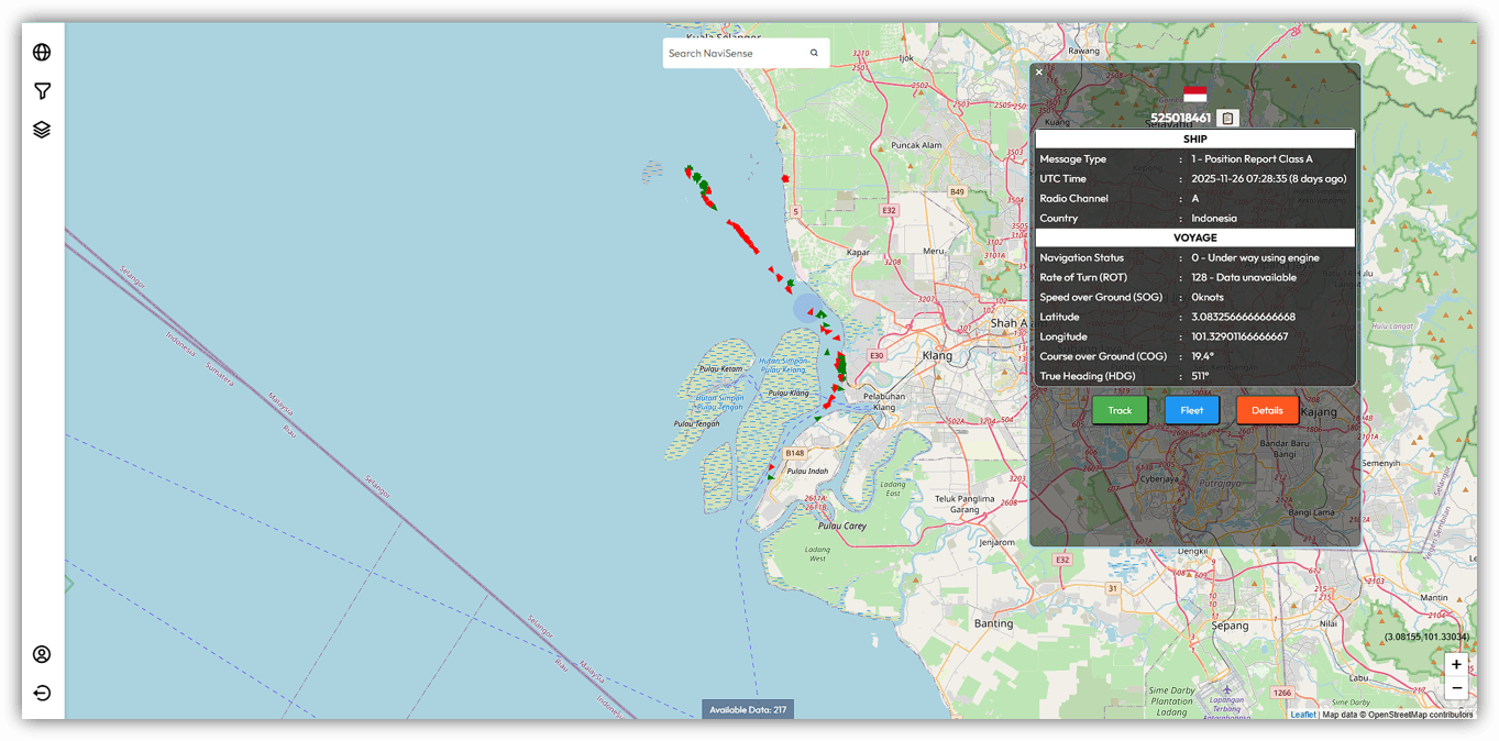
Live Maritime Situational Awareness

Visualise vessel positions and maritime activity through the Navisense operational interface. Data availability and coverage depend on connected terrestrial and satellite AIS sources.

Beta operational interface

Product Suite

Three Products, One Maritime Intelligence Stack

Deploy the products independently or combine them to support vessel-data collection, operational monitoring and maritime-system integration.

Navisense
Maritime Intelligence Platform
IMAGE PLACEHOLDER — Navisense interface

A maritime-data platform that combines live and historical AIS information into a unified operational view for vessel monitoring, analysis and system integration.

Key Capabilities

  • Live vessel monitoring and track visualisation
  • Historical vessel-track review
  • Geofences, watchlists and configurable alerts
  • REST API and real-time data-stream integration
  • Role-based user access
  • Data export for further analysis

Best Suited For

Maritime operators, analysts, port teams and system integrators.

NaviCube+
Satellite Payload

Coming Soon

NaviCube+ Product Visual

Product imagery and additional mission details are being prepared.

A compact satellite AIS receiver developed for CubeSat missions, enabling vessel-message collection beyond the practical range of terrestrial AIS infrastructure.

Key Capabilities

  • Reception of AIS VHF channels
  • Configurable spacecraft interfaces
  • Designed for low-Earth-orbit missions
  • Onboard AIS-message collection and processing
  • Mission-specific data handling and downlink
  • Engineering and flight-model options

Best Suited For

CubeSat developers, research missions and space-based AIS programmes.

NaviBased
Terrestrial AIS Receiver
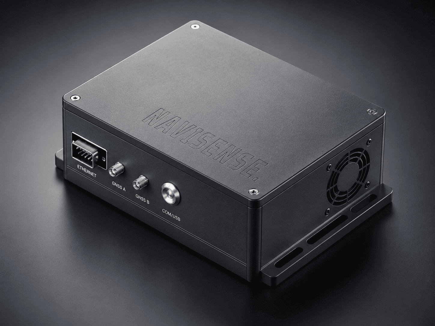
NaviBased Terrestrial AIS Receiver

A remotely deployable terrestrial AIS receiver for ports, coastal areas and maritime-monitoring sites, with local buffering and configurable communications backhaul.

Key Capabilities

  • Dual-channel AIS reception
  • GPS-referenced timing
  • Solar and battery-power options
  • Cellular or network backhaul
  • Secure remote connectivity
  • Local buffering during network interruptions
  • Remote system-health monitoring

Best Suited For

Ports, coastal authorities and remote maritime-monitoring sites.

Product Comparison

Which Solution Fits Your Maritime Operations?

Deploy each solution independently or combine them as an integrated maritime-monitoring architecture.

CapabilityNavisenseNaviCube+NaviBased
Primary functionMaritime data, visualisation and analyticsSpace-based AIS receptionTerrestrial AIS reception
DeploymentCloud or private environmentLow-Earth-orbit spacecraftCoastal, port or remote site
Primary data sourceIntegrated AIS data feedsSatellite-received AIS messagesShore-received AIS messages
Coverage roleData fusion and operational visibilityWide-area maritime collectionLocal and coastal monitoring
ConnectivityWeb interface, API and data streamsMission-specific spacecraft interfaceCellular, Ethernet or secure VPN
Data outputTracks, alerts, reports and exportsRaw or decoded AIS messagesLive AIS data and receiver health
Historical analysisSupportedThrough the connected data platformThrough the connected data platform
AlertingConfigurable alerts and watchlistsHandled by the connected platformHandled by the connected platform
Remote monitoringUser, feed and service monitoringSpacecraft-system dependentReceiver-health monitoring
IntegrationREST API and streaming interfacesMission-specific payload interfaceNavisense or third-party systems
Typical usersOperators, analysts and integratorsSatellite developers and researchersPorts and maritime agencies
Delivery modelSoftware service or private deploymentPayload procurement and integrationSite hardware deployment

Receiver Network

Coverage and Receiver-Network Planning

NaviBased supports expansion of terrestrial AIS visibility around ports, waterways and remote coastal locations. Coverage can also be supplemented by compatible satellite AIS data sources.

  • Dual-channel AIS reception
  • GPS-referenced timing
  • Secure communications backhaul
  • Local data buffering for intermittent connectivity
  • Remote receiver-health monitoring
  • Site-specific coverage assessment
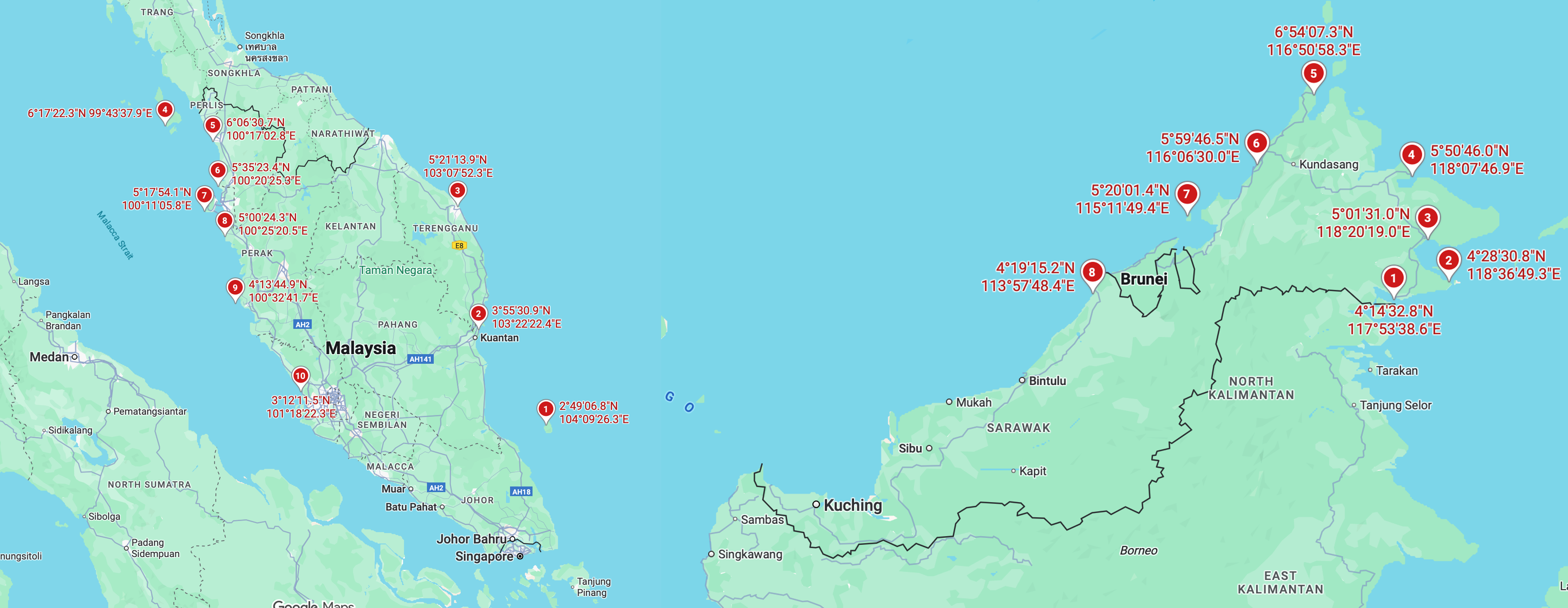
NaviBased deployment locations and receiver-network coverage

Indicative deployment and receiver-network visualisation. Actual coverage depends on site conditions, antenna placement and communications availability.

System Integration

Designed for Maritime-System Integration

Access vessel information through secure APIs and data streams for integration with operational dashboards, analytics tools and maritime-information systems.

Developer API

Illustrative vessel-data response

vessel-data.json
GET /api/v1/vessels
Authorization: Bearer YOUR_API_KEY

{
  "count": 2,
  "vessels": [
    {
      "mmsi": "533123456",
      "latitude": 3.1200,
      "longitude": 101.6500,
      "speed_over_ground": 12.4,
      "course_over_ground": 182.0,
      "timestamp": "2026-07-29T08:30:00Z"
    }
  ]
}

Security and Deployment Options

Configurable according to project requirements

Access Control

Role-based access and controlled user permissions.

API Authentication

Secure credentials and configurable API-access controls.

Encrypted Transfer

Protected data transfer between connected services.

Audit and Monitoring

Activity logging and service-monitoring options.

Network Restrictions

IP allow-listing and controlled network-access options.

Deployment Flexibility

Cloud, private-environment or project-specific deployment options.

Available security and deployment features depend on the selected service configuration and final project requirements.

Maritime Intelligence Enquiry

Request a Maritime Intelligence Demonstration

Tell us about your maritime-monitoring requirements, area of interest and preferred solution. Our team will review your request and arrange a suitable discussion or demonstration.

Prefer email? Contact us at hello@arl-navisense.com

By submitting this form, you agree to be contacted regarding Altair Research Lab maritime-intelligence products and services.